Creating Resilience to a Floodplain-Wetland Five years of - - PowerPoint PPT Presentation

creating resilience to a floodplain wetland
SMART_READER_LITE
LIVE PREVIEW

Creating Resilience to a Floodplain-Wetland Five years of - - PowerPoint PPT Presentation

Creating Resilience to a Floodplain-Wetland Five years of interdisciplinary Complex in a Rapidly Developing Urban monitoring informed Setting through Enhancement of Beaver- the development of Habitat Processes a passive, natural restoration


slide-1
SLIDE 1

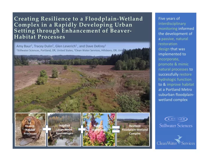
Resilient Floodplain-Wetland Complex Beaver- Habitat Processes Installed Large Wood Assemblages Native Vegetation

Creating Resilience to a Floodplain-Wetland Complex in a Rapidly Developing Urban Setting through Enhancement of Beaver- Habitat Processes

Five years of interdisciplinary monitoring informed the development of a passive, natural restoration design that was implemented to incorporate, promote & mimic natural processes to successfully restore hydrologic function to & improve habitat at a Portland Metro suburban floodplain- wetland complex

Amy Baur1, Tracey Dulin2, Glen Leverich1 , and Dave DeKrey1

1Stillwater Sciences, Portland, OR, United States, 2Clean Water Services, Hillsboro, OR, United States

slide-2
SLIDE 2

Leif Burge Matt Wood Joe Kennedy Shawn Kilpatrick1

UPPER VERNON CREEK

FLOOD RESPONSE AND RECOVERY: FROM CONCRETE FLUME TO NATURALIZED CHANNEL

slide-3
SLIDE 3

Removing Powerdale and Middle Fork Nooksack River Dams:

Designing Riverbeds in High Energy Environments

Paul DeVries Ph.D. PE

slide-4
SLIDE 4

RESTORING WET CONDITIONS TO A DEGRADED MEADOW SYSTEM

Ben Davis, Alta Science & Engineering Brenda Erhardt, Latah Soil & Water Conservation District

slide-5
SLIDE 5

Geomorphic Response to the Implementation of Fish Passage

Keith Binkley Manager of Natural Resources Snohomish County Public Utility District

slide-6
SLIDE 6

Integrating Large Wood Jams into Hydraulic Models: Evaluating a Porous Plate Modeling Method

Roby Ventres-Pake, Matt Nahorniak, Natalie Kramer, Jennifer O’Neal, Tim Abbe

slide-7
SLIDE 7

Bill Mavros 1, T. Dalziel, L. Werre, and C. Fisher 1

148 North Solutions, Inc., 909 Boat St., Seattle, WA. 98105

bmavros@48NorthSolutions.com

slide-8
SLIDE 8

water resource specialists

Effects of the Elwha River Dam Removals on the US 101 Bridge

Casey Kramer, PE1, Matt George, EIT1 and Julie Heilman, PE2;

1 Northwest Hydraulic Consultants, Olympia, WA, 2 WSDOT, Olympia, WA

slide-9
SLIDE 9

Remote Sensing as an Effective Tool for Streambank Erosion Assessment and Quantification

Forrest Williams1, Peter Moore1, Thomas Isenhart1

2009 Bankline 2009 Bankline Identified Erosion

2009 2009 2018

1Iowa State University, Ames IA: forrestw@iastate.edu

slide-10
SLIDE 10

X S _ 1 XS_9 X S _ 7 X S_6 X S_5 XS_8 X S_4 XS_3 XS_2 XS_1 XS_12 X S _ 1 1 X S _ 1 4 X S _ 1 3

Legend

Surface Mixing Line Measurement Cross-Sections

Suspended Sediment Concentration (mg/L)

16.15 1.35

slide-11
SLIDE 11

2D BED SEDIMENT MODELING OF A REACH ON THE SAGAVANIRKTOK RIVER, ALASKA

ISAAC LADINES HORACIO TONIOLO UNIVERSITY OF ALASKA FAIRBANKS

slide-12
SLIDE 12

Presented by: Michael Rafferty, Otak Luke Swan, Inter-Fluve

Designing for Resiliency:

A Case Study from Colorado’s Front Range

slide-13
SLIDE 13

USING REMOTE SENSING TO EVALUATE EFFECTIVENESS AND BUILD BETTER PROJECTS

MONITORING RESTORATION AT THE WATERSHED SCALE Scott Katz1, Jen O’Neal1, Julia Jay1, Robby Dohrn1,

Colin Riordan1, Susan Dickerson-Lange1, and Alex Levell2

1 2

slide-14
SLIDE 14

Corey Johnson Dominc Baraskoff Trenton Nett Brian Wise Students of Gonzaga University Project Advisor: Dr. Sue Niezgoda

The Lands Council and US Fish & Wildlife Service Project Liaisons: Joe Cannon and Brian Walker

USING UNMANNED AERIAL VEHICLE AND STRUCTURE-FROM- MOTION AERIAL PHOTOGRAMMETRY TO MONITOR SEDIMENT TRAPPING BY BEAVER DAM ANALOGS IN EASTERN WASHINGTON

slide-15
SLIDE 15

Experimental testing of employing large grains as a bank erosion mitigation technique

Caitlin Tatham, University of British Columbia, Paul Villard, Geo Morphix Ltd., Brett Eaton, University of British Columbia

Funded through a MITACS Accelerate Grant and NSERC Discovery Grant in partnership with GEO Morphix Ltd.

slide-16
SLIDE 16

Remote Geomorphology and Vegetation Monitoring

Tom Smrdel, MS | Fluvial Geomorphologist PLATTE RIVER RECOVERY IMPLEMENTATION PROGRAM

USDA Photo by John Noll

slide-17
SLIDE 17

Large Wood Helicopter Loading Project – Promoting Natural Processes for Spring Run Chinook in Northern California

Dave Bandrowski, Aaron Martin, Eric Wiseman – Yurok Tribe Josh Smith – The Watershed Center

slide-18
SLIDE 18

Powell Butte Floodplain Anastomosing System Concept and 2D Hydrodynamic Modeling

Mason Lacy, MS, PE, CFM – Environmental Science Associates (ESA)

slide-19
SLIDE 19

Increasing Snake River Cutthroat Spawning Habitat Through Restoration and Effective Monitoring

By: Jason Chircop & Katherine Salsbury

slide-20
SLIDE 20

Topo-bathymetric LiDAR for River Restoration: Tucannon River Case Study

Cassie Meigs, Kris Fischer, Kris Buelow, & Mischa Hey

slide-21
SLIDE 21
slide-22
SLIDE 22

Design and Construction of Spawning and Off-channel Rearing Habitat on a Flow-Regulated River

Barry Tanaka, MS, PE (ESA) | Michael Strom, MS (ESA) | Rocko Brown, PhD (Cramer Fish Sciences)

slide-23
SLIDE 23

Using Fluvial Geomorphology to Streamline Cultural Resources Studies

Patrick Reed, Tait Elder & Martin Fisher