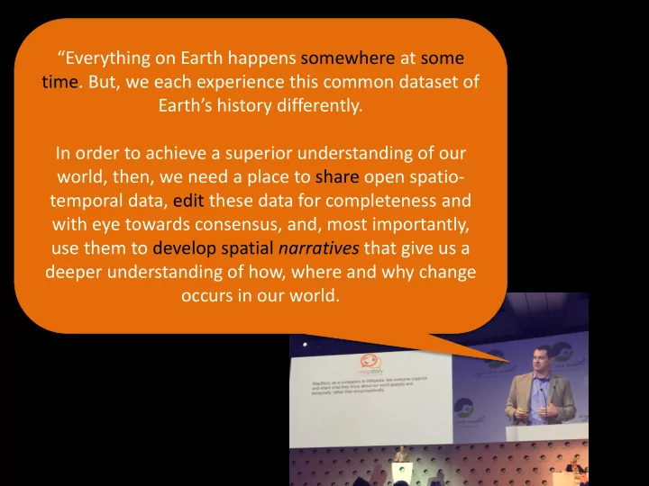
In order to achieve a superior understanding of our world, then, we - - PowerPoint PPT Presentation

in order to achieve a superior understanding of our
SMART_READER_LITE
LIVE PREVIEW

In order to achieve a superior understanding of our world, then, we - - PowerPoint PPT Presentation

Everything on Earth happens somewhere at some time. But, we each experience this common dataset of Earths history differently. In order to achieve a superior understanding of our world, then, we need a place to share open spatio- temporal


slide-1
SLIDE 1

“Everything on Earth happens somewhere at some

  • time. But, we each experience this common dataset of

Earth’s history differently. In order to achieve a superior understanding of our world, then, we need a place to share open spatio- temporal data, edit these data for completeness and with eye towards consensus, and, most importantly, use them to develop spatial narratives that give us a deeper understanding of how, where and why change

  • ccurs in our world.
slide-2
SLIDE 2

StoryLayers = openly licensed spatio- temporal datasets. MapStories = spatial narratives built using StoryLayers and other narrative elements (text annotations, photos, videos, etc) StoryTellers = The attributed users who share StoryLayers or compose MapStories.

slide-3
SLIDE 3

Original ppt mockups (mil oss?) Build a space- time data commons Empower community editing Go from spatial data to spatial narrative Empower learning & Keep improving.

slide-4
SLIDE 4

Original ppt mockups (mil oss?) Build a space- time data commons Empower community editing Go from spatial data to spatial narrative Empower Learning & keep improving.

slide-5
SLIDE 5

Original ppt mockups (mil oss?) Build a space- time data commons Empower community editing Go from spatial data to spatial narrative Empower learning & keep improving.

slide-6
SLIDE 6

Build a space- time data commons Empower community editing Go from spatial data to spatial narrative Empower Learning & keep improving.

slide-7
SLIDE 7

Let data improve. Let narratives form.

slide-8
SLIDE 8
slide-9
SLIDE 9

REST OGC

Store, retrieve, perform transactions on spatial data Standards based metadata catalog publishing

OGC CSW

OpenLayers, GeoExt, Bootstrap, AngularJS, MapStory

GeoServer

REST API OGC

GeoWebCache

Create and manage metadata, users and groups

slide-10
SLIDE 10

Build a space- time data commons Empower community editing Go from spatial data to spatial narrative Empower learning & keep improving.

slide-11
SLIDE 11

Build a space- time data commons Empower community editing Go from spatial data to spatial narrative Empower learning & keep improving.

slide-12
SLIDE 12

Build a space- time data commons Empower community editing Go from spatial data to spatial narrative Empower learning & keep improving. Basemaps StoryLayers Styles, Masks StoryBoxes Chapter 1 StoryPins Chapter 2 Chapter 3 Basemaps StoryLayers Styles, Masks StoryBoxes StoryPins Basemaps StoryLayers Styles, Masks StoryBoxes StoryPins

slide-13
SLIDE 13

Build a space- time data commons Empower community editing Go from spatial data to spatial narrative Empower learning & keep improving.

slide-14
SLIDE 14

Build a space- time data commons Empower community editing Go from spatial data to spatial narrative Empower learning & keep improving.

slide-15
SLIDE 15

Build a space- time data commons Empower community editing Go from spatial data to spatial narrative Empower learning & keep improving.

slide-16
SLIDE 16

Build a space- time data commons Empower community editing Go from spatial data to spatial narrative Empower learning & keep improving. Res

slide-17
SLIDE 17

Build a space- time data commons Empower community editing Go from spatial data to spatial narrative Empower learning & keep improving.

slide-18
SLIDE 18

Build a space- time data commons Empower community editing Go from spatial data to spatial narrative Empower learning & keep improving.

slide-19
SLIDE 19

English Social Science History Humanities

Math Geography Science Engineering

STEM

slide-20
SLIDE 20

Build a space- time data commons Empower community editing Go from spatial data to spatial narrative Empower learning & keep improving.

KEEP IMPROVING…

3 months:

  • Bulk edits (append)
  • Raster Upload
  • Geologic time support
  • Remote data streams
  • Client side icons uploads

3-12 months:

  • 4d / Cesium integration
  • Graphing/charting
  • QGIS plug-in
  • Longitudinal gazateer
  • More storytelling templates
  • Mobile editing and discovery
slide-21
SLIDE 21

Build a space- time data commons Empower community editing Go from spatial data to spatial narrative Empower learning & keep improving.

CHALLENGES

Technical

  • Achieving versioned editing at

scale

  • Geologic time support
  • Persisting styling and playback

settings for each new MapStory Social

  • Maintaining consistent team of

developers from open source communities

  • Focusing on the end-user while

also developing core features

  • Delays caused by dependencies on

third party open source projects

slide-22
SLIDE 22

Github.com/MapStory @mapstory info@mapstory.org Jonathan Marino Lead Community Organizer marino@mapstory.org Clarence Davis Lead Software Engineer cdavis@boundlessgeo.com