
SLIDE 1
Introduction to ILWIS 3 using data from Pakistan
Workshop/Training on “Earthquake Vulnerability and Multi- Hazard Risk Assessment: Geospatial Tools for Rehabilitation and Reconstruction Efforts” held at National Centre of Excellence in Geology, Peshawar, Pakistan from 13 to 31 March 2006
Ch1-p1
Associated Institute
Introduction to ILWIS 3 using a data set from Northen Pakistan.
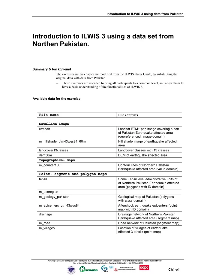
Summary & background The exercises in this chapter are modified from the ILWIS Users Guide, by substituting the
- riginal data with data from Pakistan.
− These exercises are intended to bring all participants to a common level, and allow them to have a basic understanding of the functionalities of ILWIS 3. Available data for the exercise
File name File contents
Satellite image etmpan Landsat ETM+ pan image covering a part
- f Pakistan Earthquake affected area
(georeferenced, image domain) m_hillshade_utm43wgs84_60m Hill shade image of earthquake affected area landcover13classes Landcover classes with 13 classes dem30m DEM of earthquake affected area Topographical maps m_counter100 Contour lines of Northern Pakistan Earthquake affected area (value domain)
Point, segment and polygon maps
tehsil Some Tehsil level administrative units of
- f Northern Pakistan Earthquake affected