Part 1 Re cap of events The most significant flooding in - - PowerPoint PPT Presentation

part 1 re cap of events
SMART_READER_LITE
LIVE PREVIEW

Part 1 Re cap of events The most significant flooding in - - PowerPoint PPT Presentation

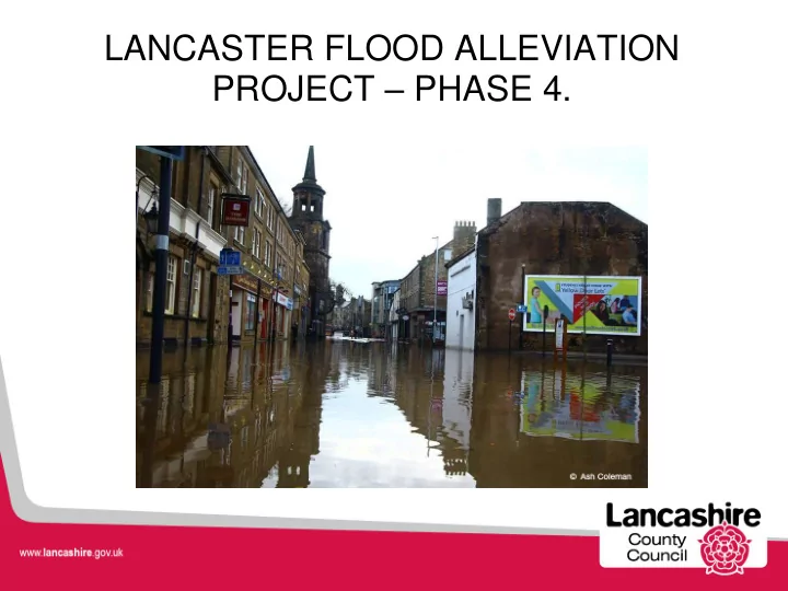
LANCASTER FLOOD ALLEVIATION PROJECT PHASE 4. Part 1 Re cap of events The most significant flooding in Lancaster was caused during Storm Desmond on the evening of the 4 th December 2015. Lancaster City was worst affected as flows


slide-1
SLIDE 1

LANCASTER FLOOD ALLEVIATION PROJECT – PHASE 4.

slide-2
SLIDE 2

Part 1 – Re cap of events

  • The most significant flooding in Lancaster was caused during Storm

Desmond on the evening of the 4th December 2015.

  • Lancaster City was worst affected as flows within the River Lune

exceeded the capacity of the channel and resulted in flooding along both banks within the area.

  • Surface water was unable to drain off into the River Lune due to water

levels / tide levels.

  • 467 reported properties flooded (227 Commercial)
slide-3
SLIDE 3
slide-4
SLIDE 4

Source : Lancaster Guardian Location : View down Chapel Street from the A6 Source : Highways Operations Location : View down Damside Street on to the main Gyratory

(1) Photos from the media

slide-5
SLIDE 5

(2) Photos from the media

Source : The Guardian Newspaper Location : Lancaster Bus Station / Gyratory / Damside Street Source : Highways operations Location : Caton Road on the morning of the 05th December 2015

slide-6
SLIDE 6

(3) Photos from the media

Source : Lancaster Guardian Location : Back Caton Road / Bulk Road on the morning of the 05th December 2015 Source : Lancaster Guardian Location : River level on the Morning of the 05th December 2015 the morning after the peak flow

slide-7
SLIDE 7

The impact of Storm Desmond

  • Both bridges were closed during the 48 hours after the storm following

reports of a 20 tonne shipping 'container' striking both Skerton and Greyhound bridges.

  • The overtopping of the River Lune also affected an electricity

substation, on Caton Road, which resulted in over 55,000 homes and businesses being without power for nearly 48 hours, many of which still experienced problems for the week after.

  • A major incident was called on the morning of the 5th December 2015

which continued until power outages were stabilised.

slide-8
SLIDE 8
slide-9
SLIDE 9
  • At storm peak on 5th December 2015, the River Lune reached its

highest ever recorded flow rate, which was a flow of 1742cumecs (m3/seconds) at the Caton gauging station.

  • Survey of the water mark inside the station suggested that the flood

level peaked at 8.15m. (Usually a range of 0.28m to 0.32m)

  • This was the highest flow ever recorded on the River Lune.
  • This was a new record for any English river.
  • Rain fall at Kirkby Lonsdale was 140mm through the period.

Initial findings of the flooding event

slide-10
SLIDE 10

Initial findings of the flooding event

  • These high river levels resulted in the River Lune overtopping its banks.
  • Combined with the inability to disperse surface water, this lead to the

flooding hundreds of properties and businesses.

  • The most significant areas affected were :

– Lancil Industrial Estate, Caton Road (and substation) – A683 Caton Road. – City Centre. – St Georges Quay area.

slide-11
SLIDE 11

Initial findings of the flooding event

  • The main cause of the flooding in the city centre is understood to be

surface water being unable to discharge.

  • The outfall which drains this area could not efficiently drain the surface

water into the River Lune due to excessive water levels and possibly working below design capacity.

  • The river contributed by over topping at Caton Road and St Georges

Quay.

  • River levels dropped but the ‘City centre’ remain tide locked with areas
  • f surface water flooding from the Highways drains and combined

drainage systems.

slide-12
SLIDE 12

What action has Lancashire County Council taken to date:

  • Inspections of all accessible drainage location to clear silt levels /

blockages.

  • De-silting of City Centre areas using high powered vactor units.
  • Extensive jetting.
  • Additional City Centre gully cleaning.
  • Minor Capital improvement repair schemes.
  • Joint inspections of Mill race entry points (LCC / United Utilities)
  • Planned boat launch to inspect outlets / inlets on the River Lune.
  • Funding application to the E.A for major investigation.

Post Flood action

slide-13
SLIDE 13

Post Flood actions (2)

Formation of a ‘Multi agency’ working group

  • The partner agencies, who have flood risk management functions have

formed a separate group outside of the LMSW to further the post flood investigations – Lancashire County Council (lead Local Flood Authority) – Lancashire County Council (Highways Authority) – The Environment Agency (Flooding from designated Main Rivers) – Lancaster City (Urban infastructure and ordinary watercourses) – United Utilities (Flooding from sewers/combined systems)

slide-14
SLIDE 14

The Mill Race, Lancaster City centre

slide-15
SLIDE 15

The History of the Mill race

  • Lancaster is home to a historic Mill Race drainage system, dating back

to 1610 when the first Lancaster Mill was present.

  • Over centuries the Mill race has been gradually covered over by

bridges, developments & houses and upstream sections were lost with the building of railway sidings at Green Ayre and Kingsway.

  • The head of the Mill race sits on the banks of the River Lune on Caton

Road (HSS hire on Caton Road) and is piped to the Kingsway site.

  • The ‘Mill Race’ is a mixture of drainage pipe (300 mm) to large scale

structures (up to 5.0 m wide x 1.8 m high) and in places, it has been restricted by services.

slide-16
SLIDE 16

(2)

  • Its outfall is usually below river at times of tidal increase or flooding and

the actual functionality of the outlet is un known.

slide-17
SLIDE 17
  • Over time, sections have been subjected to strengthening works and

the risk of collapse under heavy traffic lead to repairs to the mill race in the 1990s and the construction of new overflows and a solids traps.

  • Due to the age of the urban development in this area, parts of the

sewerage infrastructure is combined, at the lower end of the Mill race. (both surface water and foul sewage running adjacent as one system by way of over flows)

  • During an extreme rainfall event, surcharging or blockage of combined

sewerage systems has the potential to result in contaminated foul sewage flooding areas of residential property, giving significant risk to human health.

(3)

slide-18
SLIDE 18

(4)

  • Owner ship is complex with numerous developments having being

given permission over the line of the Mill race.

  • The Mill Race may be in varied states of repair and will have variable

effectiveness.

  • Some sections may be prone to failure or may be working well below

their design capacity which may have a significant impact on flood risk to homes and property.

  • The significance of the Mill Race in the future of Lancaster City centre

flood alleviation is currently un clear.

slide-19
SLIDE 19

1991 Survey line of the Mill Race

slide-20
SLIDE 20

Photograph 1 – Pitt Street, North Road

slide-21
SLIDE 21

Photograph 2 – Centre of the Carriageway on Rosemary Lane, City centre

slide-22
SLIDE 22

Photograph 3 – Junction of Damside street, Gyratory

slide-23
SLIDE 23

Photograph 4 – At the outlet at the River Lune, Damside Street

slide-24
SLIDE 24

(6)

  • We know for certain that there are significant challenges and areas of

deterioration within the Mill Race.

  • Confined spaces and hazardous conditions could explain maintenance

issues.

  • Tidal conditions make surveying and maintenance of the inlet /out

challenging.

  • There is evidence to suggest that the pipe is badly damaged in a

section near Kingsway.

  • There has been widespread development over the Mill race, which is

reliant upon developers employing the correct protection techniques.

slide-25
SLIDE 25

Part 1 : Questions ?

slide-26
SLIDE 26

Part 2 : Post Flood strategy

  • It is proposed to commission a wide scale study that will investigate the

known areas of flooding which have been identified :

  • Caton Road junction M6 out of bank flooding
  • City centre Surface water flooding
  • Lancaster Quay
  • Potentially a duration of 18 months with very challenging aspects.
slide-27
SLIDE 27

Funding

  • The E.A intend to commence Phase 3 of the Lancaster Flood

Alleviation programme along the banks of the River Lune.

  • Phase 4 has been agreed as the ‘Lancaster Flood Alleviation project’

and part 1 (Lancaster investigation) assigned for delivery as soon as possible.

  • LCC to present to the E.A at a Project Appraisal Review (PAR) as soon

as the documentation is ready, to secure funding.

  • Initial funding allocation totals £4’020’000.00.
slide-28
SLIDE 28

Objectives of the study / investigation

  • LCC needs to fully understand the flooding mechanics in the city

(source's and frequencies), and have a clearer understanding of the condition of the asset and identification of any relevant issues.

  • It will be possible for LCC to use the outcomes to prioritise further

investigations and / or actions and assess what future works are required.

  • The reports will also identify a potential range of measures which may

be introduced in the future to reduce the current level of flood risk while considering economics and cost.

slide-29
SLIDE 29

Part 1: Full Catchment Study

  • A full investigation of the surrounding catchment zones affecting

Lancaster city centre, including the River Lune, in order to fully understand their significance in the recent floods and to establish why areas flooded and what were the affecting influences.

  • To locate all known and un known water sources entering the City

centre drainage systems.

  • To include an Integrated catchment model of the City centre.
slide-30
SLIDE 30

Part 2 : Survey of the Mill Race

  • To fully survey the entire length of the Mill Race.

– Origin and alignment through the City centre. – Surveying its current conditions and highlighting defects. – Locating and charting all known / un known water sources. – Ownership and affected parties. – Outline its possible future use in Lancaster flood alleviation. – Outline potential maintenance costs of future use. This is to include full confined space access.

slide-31
SLIDE 31

Part 3 : Options and Strategy

  • Identify and present a range of options to alleviate flooding in Lancaster

in the future and how these might develop into actual programmes of work.

  • Provide full technical appraisal and presentation of findings and options

with multi assessment criteria. (pro's and Con's)

slide-32
SLIDE 32

Part 4 : Financial assessment

  • The production of a feasibility report including financial assessment /

cost benefit outlining preferred options.

  • Consider funding arrangements for any future works and assess

maintenance costs.

  • Provision of an Implementation strategy including potential programmes
  • f delivery.
slide-33
SLIDE 33

Introduction to the WEM framework

  • Water and Environmental Framework is an E.A framework that is open

to lead flood risk authorities and is suitable for all flood & coastal applications.

  • EA Commercial agreement between Lead risk authorities and leading

specialist in water and environmental management.

  • Access to the best specialist consultants, contactors & technology
  • Platform for efficiency and collaborative working under NEC 3 contracts.
slide-34
SLIDE 34

Benefits of the WEM framework

  • Contract flexibility with 4 lots (options)
  • Modelling and mapping
  • Environmental services
  • Engineering and related
  • Asset delivery and professional services
  • Access to specialists, in a recognised, facilitated framework.
  • Emergency flexibility.
  • Opportunity to incorporate further studies (Whalley / Padiham)
slide-35
SLIDE 35

Entering the WEM framework

  • Briefing to LCC by EA procurement manager.
  • ‘User’ agreement has been reviewed and accepted by procurement.
  • legal Services have reviewed to content of the ‘user’ agreement with no
  • bjections raised.
  • The next steps are to seek authorisation for procurement to enter the

WEM framework for flood and professional related services.

slide-36
SLIDE 36

Flood Investigation tender Process

  • Tendering will be via the WEM Framework (Water and Environmental

framework) following the principles of WEM.

  • The Contract will be let on a quality / cost basis in line with WEM

evaluation criteria and follow advised contractual arrangements.

  • The EA will also be involved in the full tendering, award and contractual

side of the project.

slide-37
SLIDE 37

Projects milestones and target dates

  • Notification of a key decision : Presentation of WEM framework seeking

authorisation to enter the WEM.

  • EA Project Appraisal Review to secure funding – August 2016
  • Media brief – dates and content to be resolved
  • Scope of the investigation - July 2016 to October 2016
  • Tender progress via WEM - October 2016 to November 2016
  • Contract Award investigation – December 2016
  • Commencement of the Investigation - Jan 2017