SOUTHERN REGION GRMP SITE INSPECTION FORM Slope movement has - - PDF document

southern region grmp site inspection form
SMART_READER_LITE
LIVE PREVIEW

SOUTHERN REGION GRMP SITE INSPECTION FORM Slope movement has - - PDF document

SOUTHERN REGION GRMP SITE INSPECTION FORM SITE NUMBER AND NAME: HIGHWAY & KM: PREVIOUS INSPECTION DATE: S039 - I & II Brocket Slides 3:06, 12.952 & 13.062 INSPECTION DATE: May 10, 2019 May 3, 2018 LEGAL DESCRIPTION: NAD 83


slide-1
SLIDE 1

SOUTHERN REGION GRMP SITE INSPECTION FORM Page 1 of 2

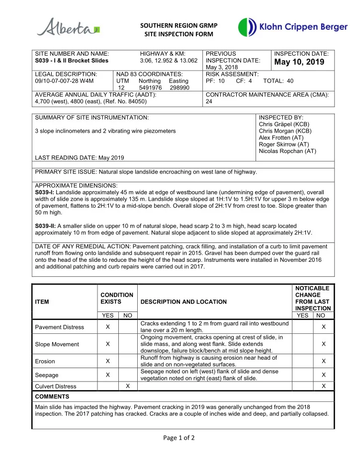
SITE NUMBER AND NAME: S039 - I & II Brocket Slides HIGHWAY & KM: 3:06, 12.952 & 13.062 PREVIOUS INSPECTION DATE: May 3, 2018 INSPECTION DATE:

May 10, 2019

LEGAL DESCRIPTION: 09/10-07-007-28 W4M NAD 83 COORDINATES: UTM Northing Easting 12 5491976 298990 RISK ASSESMENT: PF: 10 CF: 4 TOTAL: 40 AVERAGE ANNUAL DAILY TRAFFIC (AADT): 4,700 (west), 4800 (east), (Ref. No. 84050) CONTRACTOR MAINTENANCE AREA (CMA): 24 SUMMARY OF SITE INSTRUMENTATION: 3 slope inclinometers and 2 vibrating wire piezometers LAST READING DATE: May 2019 INSPECTED BY: Chris Gräpel (KCB) Chris Morgan (KCB) Alex Frotten (AT) Roger Skirrow (AT) Nicolas Ropchan (AT) PRIMARY SITE ISSUE: Natural slope landslide encroaching on west lane of highway. APPROXIMATE DIMENSIONS: S039-I: Landslide approximately 45 m wide at edge of westbound lane (undermining edge of pavement), overall width of slide zone is approximately 135 m. Landslide slope sloped at 1H:1V to 1.5H:1V for upper 3 m below edge

  • f pavement, flattens to 2H:1V to a mid-slope bench. Overall slope of 2H:1V from crest to toe. Slope greater than

50 m high. S039-II: A smaller slide on upper 10 m of natural slope, head scarp 2 to 3 m high, head scarp located approximately 10 m from edge of pavement. Natural slope adjacent to slide sloped at approximately 2H:1V. DATE OF ANY REMEDIAL ACTION: Pavement patching, crack filling, and installation of a curb to limit pavement runoff from flowing onto landslide and subsequent repair in 2015. Gravel has been dumped over the guard rail

  • nto the head of the slide to reduce the height of the head scarp. Instruments were installed in November 2016

and additional patching and curb repairs were carried out in 2017. ITEM CONDITION EXISTS DESCRIPTION AND LOCATION NOTICABLE CHANGE FROM LAST INSPECTION YES NO YES NO Pavement Distress X Cracks extending 1 to 2 m from guard rail into westbound lane over a 20 m length. X Slope Movement X Ongoing movement, cracks opening at crest of slide, in slide mass, and along west flank. Slide extends downslope, failure block/bench at mid slope height. X Erosion X Runoff from highway is causing erosion near head of slide and on non-vegetated surfaces. X Seepage X Seepage noted on left (west) flank of slide and dense vegetation noted on right (east) flank of slide. X Culvert Distress X X COMMENTS Main slide has impacted the highway. Pavement cracking in 2019 was generally unchanged from the 2018

  • inspection. The 2017 patching has cracked. Cracks are a couple of inches wide and deep, and partially collapsed.
slide-2
SLIDE 2

SOUTHERN REGION GRMP SITE INSPECTION FORM Page 2 of 2

Slope movement has extended onto the pavement and cracks have reached the white line. Cracking of highway surface indicates that retrogression of head scarp into the highway lanes will continue. Water flow off the highway is eroding the placed gravel. Ongoing need for patching and asphalt curb repair. Seepage inferred at slide location based on dense vegetation zone at east flank. Seepage observed on the access road constructed for drilling investigation. Bench in slide mass located approximately mid slope and appears to be the location of the failure plane just above the elevation of bedrock outcrops on natural slopes on flanks of slide zone, with the slide mass falling to the toe of the natural slope. Vegetation (shrubs, grass) present on slide mass except where cattle trails, landslide cracking and scarps are

  • present. Numerous tension cracks and scarps present on slide mass. The access roads constructed for drilling

have revegetated. Cattle trails on slide are obscuring some of the tension cracks. The second site (S039-II) is located to the east of the main slide site. Small slide in upper slope which extends into the ditch, causing runoff to flow onto the slide area. The second site was not inspected in 2019. In the short-term, the asphalt curb should be reestablished as required to limit pavement drainage onto the slide

  • zone. The curb may need to be protected from snowplows by a high-tension-cable barrier.

Design of remedial measures and preparation of tender documents has been completed by KCB. The proposed repair option includes soil nails and surface mesh to stabilize the highway embankment.

slide-3
SLIDE 3

Alberta Transportation Southern Region GRMP S039 - I & II Brocket Slides Hwy 3:06, km 12.952 & 13.062

2019 S039 Inspection Photos.docx Page 1 A05115A03 July 2019

Photo 1 Pavement cracking across the highway proximal to the slide. Photo was taken facing west on May 10, 2019. Photo 2 Head scarp impacting the highway. The 2017 patching has cracked. Photo was taken facing west on May 10, 2019.

slide-4
SLIDE 4

Alberta Transportation Southern Region GRMP S039 - I & II Brocket Slides Hwy 3:06, km 12.952 & 13.062

2019 S039 Inspection Photos.docx Page 2 A05115A03 July 2019

Photo 3 Instrumentation installed on a bench constructed mid slope in the middle of the slide area (red circle). Photo was taken facing northeast on May 10, 2019. Photo 4 Cracks on the ground on instrumentation bench, partially infilled due to sediment runoff and vegetation. SI readings indicate movement is directed approximately 40° from the downslope direction (perpendicular to the cracking). Photo taken facing northeast on May 10, 2019.

slide-5
SLIDE 5

Alberta Transportation Southern Region GRMP S039 - I & II Brocket Slides Hwy 3:06, km 12.952 & 13.062

2019 S039 Inspection Photos.docx Page 3 A05115A03 July 2019

Photo 5 Head scarp of slide to the west of the main slide area, located between the highway and fence line. Photo was taken facing northwest on May 10, 2019.

slide-6
SLIDE 6

" 5

?

" 5

?

" 5

BH16-03 (SI) BH16-02 (VW) BH16-01 (SI) BH16-04B (SI) BH16-04A (VW) Source: Esri, DigitalGlobe, GeoEye, Earthstar Geographics, CNES/Airbus DS, USDA, USGS, AeroGRID, IGN, and the GIS User Community

File: Z:\A\EDM\A05115A03 ABT Southern Region GRMP\400 Drawings\2019\2. Section B\MXD\S039_190527.mxd

SOUTHERN REGION GEOHAZARD RISK MANAGEMENT PROGRAM

Site Plan S039 - West Brocket Slide Hwy 3:06, km 12.952

A05115A03 1

PROJECT TITLE PROJECT No. FIG No. CLIENT

³

100 Metres

  • 1. HORIZONTAL DATUM: NAD83
  • 2. GRID ZONE: UTM Zone 12N
  • 3. IMAGE SOURCE: World Imagery, ArcGIS Online.

Source date: January 2015. SCALE

NOTES:

Time: 16:39:12 PM Date: June 13, 2019

1:2,000

Hwy 3:06

D

To Brocket

D

To Jct Hwy 785

Pincher Creek Legend ?

Vibrating Wire Piezometer

" 5

Slope Inclinometer Slide Flow Direction

! ! ! ! ! ! !

^ _

BRITISH COLUMBIA NORTHWEST TERRITORIES SASKATCHEWAN U.S.A

Calgary Edmonton Red Deer High Level Fort McMurray Grande Prairie Lethbridge

! ! ! ! !

^ _

07-28 W4M 08-28 W4M 07-29 W4M 06-28 W4M 08-29 W4M 06-29 W4M 05-28 W4M 05-29 W4M 09-29 W4M 09-28 W4M

U V

785

U V

6

U V

507

U V

3

U V

510

U V

786

Chokio Brocket Pincher Hartleyville

D

Approximate location

  • f bedrock outcrop

D

Approximate location

  • f bedrock outcrop

D

Main landslide

D

Asphalt curb

D

Slide

Project Location