
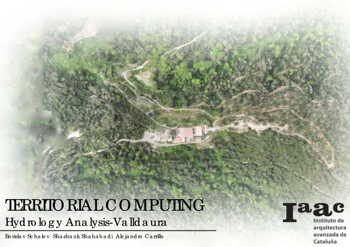
SLIDE 1
T E RRI T ORI AL COMPUT I NG
Hydro lo g y Ana lysis-Va llda ura
Bo risla v Sc ha le v Sha sha nk Sha ha b a di Ale ja ndro Ca rrillo
T E RRI T ORI AL COMPUT I NG Hydro lo g y Ana lysis-Va llda - - PowerPoint PPT Presentation
T E RRI T ORI AL COMPUT I NG Hydro lo g y Ana lysis-Va llda ura Bo risla v Sc ha le v Sha sha nk Sha ha b a di Ale ja ndro Ca rrillo 1 Ste p T he first ste p we did wa s to e xtra c t a n ima g e fro m g o o g le e a rth so we
Bo risla v Sc ha le v Sha sha nk Sha ha b a di Ale ja ndro Ca rrillo
1 Ste p
T he first ste p we did wa s to e xtra c t a n ima g e fro m g o o g le e a rth so we c a n c re a te a lo w re so lutio n te rra in o f the site with Gho wl .So with this initia l da ta we c a n sta rt a na lysing the wa - te rflo w a nd slo pe s o f the site .
2 Ste p
Afte r tha t we a lso g e ne ra te a g ra ss- ho ppe r de finitio n fo r c re a ting a flig ht pa th fo r the dro ne so we c a n g a the r mo re pre c ise da ta fo r a na - lysing the te rra in
HIGHEST ANGLE MID ANGLE LOWEST ANGLE
We c re a te d a g ra ssho ppe r de finitio n fo r the slo pe a na lysis ,whe re the g ra die nt displa ys the a ng le o f the slo pe o f e a c h ve rtic e o f the me sh we a re a na lysing . T he b lue c o lo r is re pre se nting the lo we st a ng le a nd the re d the ste e pe st a ng le
WATERFLOW
We g e ne ra te d a wa te rflo w a na lysis de finitio n tha t le t us visua lize the wa y tha t wa te r flo ws thro ug h the te rra in
Afte r se ve ra l flig hts with the dro ne s a nd a na lysing a ll the da ta with missio n pla nne r we we re a b le to g e n- e ra te a hig h re so lutio n ima g e a nd a lso a 3d mo de l o f the site so we c a n run a g a in a ll the g ra ssho ppe r de finitio n with a hig he r pre ssi- c io n
We ha d to re duc e the a re a o f a na lysis b e c a use
we de c ide d to se le c t the a re a c lo se to the ho use to do o ur a na lysis.
SELECTED AREA
There were several gaps in between the mesh which din’t form a singular surface so we tried to fill the holes with a delauny mesh. But since this had over 16000 individual components we had to look for other options to analyse the terrain.
So to get a terrain we broke the mesh into its components to make a surface with the mesh points
IAAC VALLDAURA RESTAURANT FIRST ANALYSED AREA SECOND ANALYSED AREA
IAAC VALLDAURA RESTAURANT FIRST ANALYSED AREA SECOND ANALYSED AREA
IAAC VALLDAURA RESTAURANT FIRST ANALYSED AREA SECOND ANALYSED AREA
PERSPECTIVE TOP VIEW
DETAILED SLOPE ANALYSIS OF THE TERRAIN
MODIFIED TERRAIN
CONTROLLED WATERFLOW DUE TO TERRAIN MANIPULATION