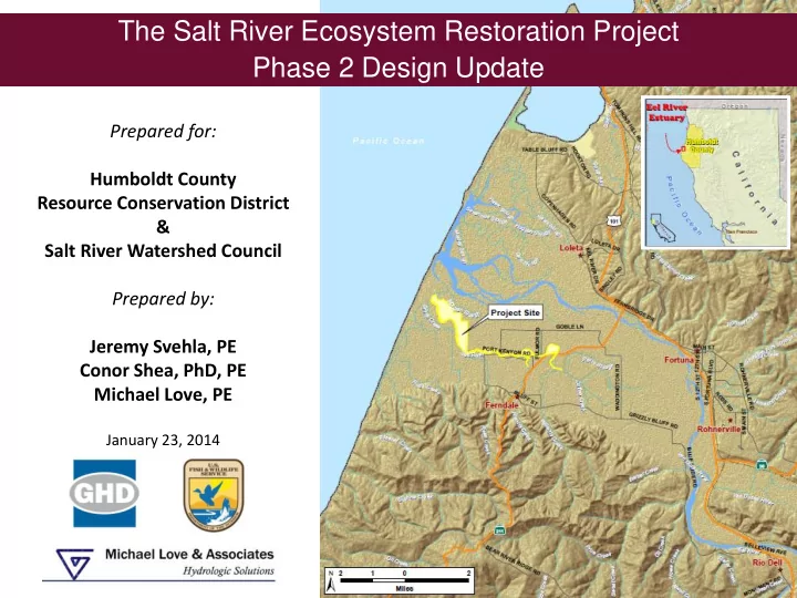
SLIDE 1 Prepared for: Humboldt County Resource Conservation District & Salt River Watershed Council Prepared by: Jeremy Svehla, PE Conor Shea, PhD, PE Michael Love, PE
January 23, 2014
The Salt River Ecosystem Restoration Project Phase 2 Design Update
SLIDE 2 Acknowledgments
KAM AMMAN AN HYDRO DROLO LOGY GY & E ENGINEE GINEERING, ING, INC
McBain & Trush
Salt River Watershed Council
SLIDE 3
Presentation Overview
1. Project Overview 2. Phase 2 Design Goals/Objectives 3. Channel Design Development – Geomorphic Channel Grading – Instream Wood – Revegetation 4. Adaptive Management Plan (AMP) 5. Implementation Considerations 6. Q&A
SLIDE 4
- 1. Riverside Ranch Tidal Marsh
Restoration (Phase 1)
- 2. Salt River Channel and Riparian
Floodplain Corridor Restoration (Phase 2)
- 3. Upslope Sediment Reduction
Program
- 4. Adaptive Management Plan –
Riverside Ranch, Channel and Riparian Floodplain, Sediment Maintenance and Management Primary Project Components
Project Development Watershed-Based and Ecosystem-Scale
Upslope Sediment Reduction Program Riverside Ranch Tidal Marsh Restoration Salt River Channel and Riparian Corridor Restoration
SLIDE 5
Overall Project Goals
1. Rehabilitate the Salt River channel and adjacent riparian floodplain by increasing hydraulic conveyance and constructing habitat features that re-establish ecological processes beneficial to fish and other native species; 2. Restore historic estuarine habitat and tidal connectivity within the lower Salt River; 3. Improve water quality and drainage efficiency across the floodplain and implement long-term upslope sediment reduction; 4. Manage excess sediment loads by maximizing fluvial and tidal channel sediment transport capacity and implementing sediment management areas; 5. Initiate a long-term corridor adaptive management process that maximizes ecological restoration success in a working landscape
Overall Project Goals
SLIDE 6
Geomorphic Channel Design Rational
SLIDE 7
- Transport hyperloads of sediment through low-
slope channel
SOURCE AND TRANSPORT REACH DEPOSITIONAL REACH
Geomorphic Channel Design Rational
SLIDE 8
Sediment Supply and Deposition Rates
SLIDE 9
Most Sediment Comes with High Discharge
SLIDE 10
High Flow Events Occur Only a Few Days a Year
SLIDE 11
Phase 2: Salt River Channel and Riparian Floodplain Corridor Geomorphic and 2-D Hydraulic Modeling Design Approach
SLIDE 12 Riparian Planting along Channel
Channel Cross-section Design
SLIDE 13
Effective Discharge: 86 cfs Exceeded 27 days/year
Channel Cross-section Design
SLIDE 14
Full Active Channel Discharge: 138 cfs Exceeded 13 days/year
Channel Cross-section Design
SLIDE 15
Berm Overtopping Discharge: 400 cfs Exceeded 1 day/year
Channel Cross-section Design
SLIDE 16 Riparian Planting along Channel
Large Wood Used to Create Geomorphic Features
Large Wood Design Considerations
- 1. Supports Geomorphic Channel Functions
- 2. Provides Aquatic Habitat Diversity
- 3. Reuses Onsite Materials
- 4. Designed for Minimal Maintenance
- 5. Meets Permit Requirements
SLIDE 17
Log Sill Structures (Side Channel Inlet)
SLIDE 18 Revegetation Design Approach
Revegetation Considerations
- 1. Compatible with geomorphic design and adjoining land uses
- 2. Short Term Erosion Control/SWPPP Compliance
- 3. Long Term Succession to Suppress Invasive Species
- 4. Permit Requirements (Planting Area and Species)
- 5. Freshwater and Brackish Habitats
SLIDE 19
Revegetation Design Approach
SLIDE 20
Revegetation Design Approach
SLIDE 21
- One of the Four Project Components
- Monitoring and management structure
- Identify monitoring components, triggering mechanisms and
potential actions
- Relates project performance to goals & objectives
- Includes Roles for all Stakeholders
- Watershed Council
- HCRCD
- Landowners
- Regulatory Group
- Funders
- Technical Advisory
- Included in 10-year Permits
- Basis to Pursue Long-term Funding Opportunities
Adaptive Management Plan (AMP) Long-term Monitoring and Management Program
SLIDE 22
Adaptive Management Plan (AMP) Long-term Monitoring and Management Program
The Structure The Process