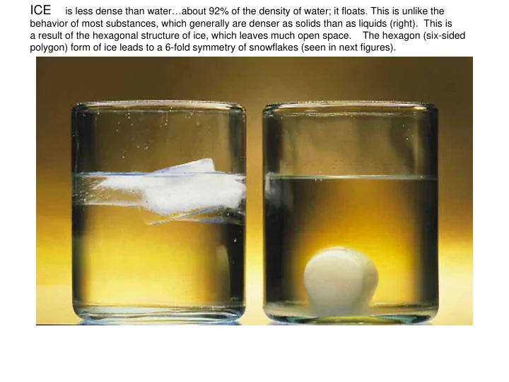
SLIDE 1 ICE is less dense than water…about 92% of the density of water; it floats. This is unlike the
behavior of most substances, which generally are denser as solids than as liquids (right). This is a result of the hexagonal structure of ice, which leaves much open space. The hexagon (six-sided polygon) form of ice leads to a 6-fold symmetry of snowflakes (seen in next figures).
SLIDE 2
The shape of the water molecule and the hydrogen bond (the electrostatic attraction between the oppositely charged parts of two nearby molecules): these determine the shape of the ice crystal.
http://www.indiana.edu/~g131/struct.html
SLIDE 3 "Under the microscope, I found that snowflakes were miracles of beauty; and it seemed a shame that this beauty should not be seen and appreciated by others. Every crystal was a masterpiece of design and no
- ne design was ever repeated., When a snowflake melted, that design was
forever lost. Just that much beauty was gone, without leaving any record behind." Wilson "Snowflake" Bentley 1925
SLIDE 4
SLIDE 5 The 3000m thick ice cap contains a record of more than 100,000 years of Earth’s climate; this is about the length of the ice-age
- cycle. Ice-cores are drilled
at the sites shown at left, all the way to bed-rock, and the annual layers of ice (compacted from each winter’s snowfall) tell us much about climate, year by year.
SLIDE 6 "About 85 percent of Greenland is covered by a massive ice sheet with an area of about 1,736,000 square kilometers and an average thickness of about 1,500 meters. The volume
- f ice in the Greenland sheet is estimated to
be about 2,600,000 cubic kilometers -- enough ice to raise sea levels by 6.4 meters if it all were to melt. The Greenland ice cap is
- nly about one-seventh the size of the
Antarctic ice sheet." Imagine how much sea level would rise if that ice sheet were to melt!
SLIDE 7
Near Nuuk, the capital of Greenland
SLIDE 8
Research vessel Knorr and iceberg in the Labrador Sea
SLIDE 9
A glacier on Ellesmere Island flows out over the ocean (smooth white sea-ice covered), and icebergs ‘calve’ off in great numbers. Sea-ice is usually just a few meters thick, so the icebergs often move through it without much resistance.
SLIDE 10
In 1912 the ship Titantic, on its maiden voyage, collided with an iceberg south of Newfoundland, farther south than is normal. Since then an International Ice Patrol counted icebergs moving south across 48N latitude. Note the great variation in different decades.
SLIDE 11
Let ’s remove t he ice Let ’s remove t he ice (only t emporarily)
(only t emporarily)
Konrad Steffen
SLIDE 12
An ice core brought up at one of the drilling sites in Greenland.
SLIDE 13 Glaciers are retreating world-wide. This is a plot showing the movement in km of the end of glaciers round the world. Almost all are retreating. Changes in both temperature and precipitation may be involved,yet with so many receding it is likely that warming temperatures are the principal cause. Note that the glacier melt-back seemed to begin before 1900, which means that greenhouse gases may not be the
- nly culprit source: IPCC 2001
SLIDE 14 Humboldt , Pet ermann, 79 Nort h and J akobshavn glaciers are t he “plugs in t he bat ht ub” I f t he grounding line of t hese glaciers ret reat f urt her, and increase in ice f lux is possible. This scenario has now been
I sbrea increase in velocit y, surf ace lowering, and ret reat
- f grounding line.
- Dr. Konrad Steffen of University of Colorado finds
that the major glaciers in Greenland are accelerating in their flow to the sea; if this continues it could let the sea flow in underneath, since the rock surface of Greenland is below sea level in the blue regions.
SLIDE 15
Floating sea-ice and the Greenland ice-cap
SLIDE 16
Declining ice cover in the Arctic
SLIDE 17
Narsaq, south Greenland (images from John Rasmussen)
SLIDE 18
SLIDE 19
SLIDE 20
SLIDE 21
SLIDE 22
Icebreaking ships in the Arctic
SLIDE 23 Baffin Bay is west of Greenland; on the left it is covered with sea-ice as far south as Davis Strait. There you can see the winds blowing over open ocean (dark). The lines of cloud south of the ice edge indicate convection, as the ocean warms the frigid Arctic air. Right-hand image shows eddies in both ocean ice-edge (left) and atmospheric cloud (right)
Greenland Baffin Island Convection in the lower atmosphere where cold air first passes over warm
- cean: the beginning of the
deep convection process that creates Labrador Sea Water
SLIDE 24
A fjord near Nuuk late in a June evening