About AMETI The Auckland Manukau Eastern Transport Initiative - - PowerPoint PPT Presentation

about ameti
SMART_READER_LITE
LIVE PREVIEW

About AMETI The Auckland Manukau Eastern Transport Initiative - - PowerPoint PPT Presentation

About AMETI The Auckland Manukau Eastern Transport Initiative (AMETI) is a group of projects that will give residents of South Eastern suburbs improved transport Merton Rd Key choices and better connect them to the rest of Auckland. Stage 1


slide-1
SLIDE 1

The Auckland Manukau Eastern Transport Initiative (AMETI) is a group of projects that will give residents of South Eastern suburbs improved transport choices and better connect them to the rest of Auckland.

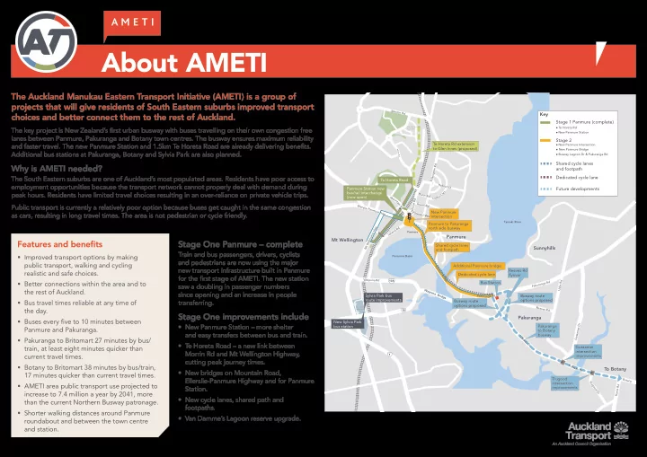
The key project is New Zealand’s first urban busway with buses travelling on their own congestion free lanes between Panmure, Pakuranga and Botany town centres. The busway ensures maximum reliability and faster travel. The new Panmure Station and 1.5km Te Horeta Road are already delivering benefits. Additional bus stations at Pakuranga, Botany and Sylvia Park are also planned.

Why is AMETI needed?

The South Eastern suburbs are one of Auckland’s most populated areas. Residents have poor access to employment opportunities because the transport network cannot properly deal with demand during peak hours. Residents have limited travel choices resulting in an over-reliance on private vehicle trips. Public transport is currently a relatively poor option because buses get caught in the same congestion as cars, resulting in long travel times. The area is not pedestrian or cycle friendly.

Additional Panmure bridge

Panmure

Panmure Basin Tamaki River

Sylvia Park Shopping Centre The University of Auckland

P i l l k i n g t

  • n

R d Dunn Rd G r e e n R d Pleasant View Jellicoe Rd

Morrin Rd

C

  • a

t e s C r e s H

  • b

s

  • n

S t

Panmure Bridge

Merton Rd Ellerslie Panmure Hwy Mt Wellington Hwy Wa i p u n a R d Mou n t a i n R d Ireland Rd L a g

  • n

D r P a k u r a n g a R d Harris Rd Udys Rd Reeves Rd Gossamer Dr T r u g

  • d

D r Bo t a n y W a i p u n a B r i d g e T i R a k a u D r Pakuranga Rd T i R a k a u D r

New Panmure intersection Te Horeta Road Panmure Station new bus/rail interchange (now open) Panmure to Pakuranga north side busway

10

Sylvia Park bus route improvements

10A

Bus Station Gossamer intersection improvements

1

Shared cycle lanes and footpath Busway route

  • ptions proposed

Te Horeta Rd extension to Glen Innes (proposed) Pakuranga to Botany busway New Sylvia Park bus station Trugood intersection improvements Dedicated cycle lane Busway route

  • ptions proposed

Reeves Rd flyover

Mt Wellington Panmure Sunnyhills Pakuranga To Botany

About AMETI

Features and benefits

  • Improved transport options by making

public transport, walking and cycling realistic and safe choices.

  • Better connections within the area and to

the rest of Auckland.

  • Bus travel times reliable at any time of

the day.

  • Buses every five to 10 minutes between

Panmure and Pakuranga.

  • Pakuranga to Britomart 27 minutes by bus/

train, at least eight minutes quicker than current travel times.

  • Botany to Britomart 38 minutes by bus/train,

17 minutes quicker than current travel times.

  • AMETI area public transport use projected to

increase to 7.4 million a year by 2041, more than the current Northern Busway patronage.

  • Shorter walking distances around Panmure

roundabout and between the town centre and station.

Key Stage 1 Panmure (complete)

Te Horeta Rd New Panmure Station

Stage 2

New Panmure Intersection New Panmure Bridge Busway Lagoon Dr & Pakuranga Rd

Shared cycle lanes and footpath Dedicated cycle lane Future developments

Stage One Panmure – complete

Train and bus passengers, drivers, cyclists and pedestrians are now using the major new transport infrastructure built in Panmure for the first stage of AMETI. The new station saw a doubling in passenger numbers since opening and an increase in people transferring.

Stage One improvements include

  • New Panmure Station – more shelter

and easy transfers between bus and train.

  • Te Horeta Road – a new link between

Morrin Rd and Mt Wellington Highway, cutting peak journey times.

  • New bridges on Mountain Road,

Ellerslie-Panmure Highway and for Panmure Station.

  • New cycle lanes, shared path and

footpaths.

  • Van Damme’s Lagoon reserve upgrade.
slide-2
SLIDE 2

Auckland Transport plans to apply for consents for the projects between Panmure roundabout and the intersection of Pakuranga Road/Ti Rakau Drive in April 2015. The projects include

  • Upgrading Panmure roundabout to an intersection with traffic lights.
  • Building the Panmure Station to Pakuranga section of New Zealand’s first dedicated urban

busway; separate from general traffic.

  • Building a new cycle and pedestrian link between Panmure and Pakuranga along Lagoon Drive

and Pakuranga Road.

  • Building a new Panmure busway bridge next to the existing road bridge with a wide shared

path for cyclists and pedestrians.

Additional Panmure bridge

Panmure

Panmure Basin Tamaki River Dunn Rd Green Rd Pl e a s an t V i e w Jellicoe Rd C

  • a

t e s C r e s

Panmure Bridge

R d L a g

  • n

D r Reeve s R d Waipuna B r i d g e T i R a k a u D r

New Panmure intersection Panmure to Pakuranga north side busway

10

Shared cycle lanes and footpath Dedicated cycle lane

Pakuranga Rd

Panmure Pakuranga

Stage 2a Panmure to Pakuranga

Features and benefits

  • The busway between Panmure and Pakuranga will provide a fast,

frequent and reliable way to travel between Panmure and Pakuranga and the rest of Auckland.

  • Reliable and quick transport option separate from general traffic.
  • Removal of the bottleneck at Panmure roundabout, with a safer

signalised intersection keeping traffic moving.

  • Easier to walk or cycle around Panmure. The new intersection

will have direct crossings across all roads, and will reduce walking distances, for example from the current 500m to 50m between Ireland and Mountain Roads.

  • Priority for vehicles using Lagoon Drive making it a more attractive

route for through traffic.

  • New cycle lanes and footpaths connecting Panmure and Pakuranga.
  • Avoids “pinch points” such as merging with general traffic and

pedestrian crossings leading to faster journey times.

  • An improved town centre environment and enhanced connections

with Panmure Station.

Key Stage 2a

New Panmure Intersection New Panmure Bridge Busway Lagoon Dr & Pakuranga Rd

Shared cycle lanes and footpath Dedicated cycle lane

slide-3
SLIDE 3

History and Milestones

2006 2007 2008 – 2010 2010 Dec 2010 April 2011

AMETI established by joint project partners Auckland City Council, Manukau City Council and Auckland Regional Transport Authority. Consultation

  • n preliminary
  • ptions

Consultation on preferred route/

  • ption

Consultation on design Auckland Transport established Public consultation Scheme asessment and design Public consultation Scheme asessment and design

Mar 2015 Apr 2015 Late 2015

Public consultation Notices of Requirement and resource consents lodged – Stage 2a Panmure to Pakuranga NoR publicly notified for submissions, followed by hearing

Dec 2011

Public consultation Scheme asessment and design Public consultation Scheme asessment and design

April 2012 Sep 2012 July 2013

Public consultation Scheme asessment and design Public consultation Scheme asessment and design

slide-4
SLIDE 4

Panmure Intersection

Features and benefits

  • Improves safety – bus priority
  • n dedicated busway; more

pedestrian and cyclists crossings; improves vehicular movement through intersection.

  • Town centre will be better

connected to Panmure station, with shorter walking distances.

  • On and off street cycle facilities.
  • Majority of current traffic

movements remain, however the right turn out of Jellicoe Road will be via Mountain Road/Forge Way instead.

  • Prioritises the movement of

vehicles along Lagoon Drive and Ellerslie Panmure Highway.

The new 1.5km Te Horeta Road has reduced traffic through the Panmure roundabout via Jellicoe Road and Ellerslie-Panmure Highway. This allows the roundabout to be replaced with an intersection with traffic and bus priority lane to be created. What you said

  • Crossing distances too long.
  • Want right turn from Lagoon Dr.
  • Keep Ireland Rd access.
  • Keep Jellicoe Rd open.
  • Want to be able to u-turn on Queens Rd.

What has been done

  • Staggered crossings introduced.
  • Right turn from Lagoon Dr permitted.
  • Ireland Rd access remains.
  • Jellicoe Rd open, no right turn, access to

Ellerslie-Panmure Highway via re-aligned Mountain Rd.

  • U-Turn on Queens Rd added subject to

road safety reviews.

Panmure intersection (proposed) Ellerslie Panmure Highway Ireland Rd Q u e e n s R d L a g

  • n

D r Jellicoe Rd

slide-5
SLIDE 5

Features

  • General traffic lanes reduced

to one in each direction, made possible by the new Panmure intersection improving traffic flows.

  • New access to rear of some

Queens Road shops via Korma Lane.

  • The southern side of

Lagoon Drive remains mostly untouched to avoid significant, environmental, geological and archaeological features.

  • New signalised intersections

with bus stops at Basin View Lane and Church Crescent.

  • A new access way from

Bridge Street, at the end

  • f the cul de sac, for eight

properties that currently have property access from Church Crescent.

  • Additional signalised

pedestrian crossings at Basin View Lane and Church Crescent.

  • New access via Domain Road

to Lagoon Stadium/squash courts for three properties that currently have access from Lagoon Drive.

Lagoon Drive

The busway and shared cycle and footpath (separated from busway and traffic) will be created on Lagoon Drive by widening on the northern cliff side, avoiding impacts on the basin.

Lagoon Drive Busway Typical Section

Footpath Cyclepath Two way bus lanes Traffic lanes Separation

4.3m 3.5m 3.5m 3m 3m

slide-6
SLIDE 6

Panmure Bridge

Features and benefits

  • Two 3.5m busway lanes.
  • 4.3m shared cycle/pedestrian path.
  • Viewing platforms where people can

pause safely outside of the flow of pedestrians and cyclists.

  • Preservation of historic bridge

turnstyle.

  • The new busway bridge will be

constructed 4.8m to the north of the existing Panmure Bridge. This will allow for the existing bridge’s future four lane replacement.

A new bridge is proposed on the northern side of the current Panmure Bridge to provide for the busway and a combined pedestrian and cycle path.

The existing bridge has no dedicated cycle facilities and the narrow footpath makes walking across it unpleasant. It is also too narrow to provide for a separate two lane busway. The existing bridge is scheduled for replacement in 2035 to bring it up to seismic standards. Until then the current peak time lanes will remain for private vehicles.

What you said

  • Minimise impact on the culturally significant

Mokoia Pa.

  • Provide cycle and pedestrian facilities on

new bridge.

  • Improve navigation on the Tamaki Estuary.

What has been done

  • Bridge beams designed to reduce excavation

in the pa.

  • Cycle and pedestrian facilities separated at the

Pa to avoid excavation.

  • The busway bridge will be 1.5m higher than the

existing Panmure Bridge which will minimise excavation in the historic Mokoia Pa.

  • Piers widened and bridge higher to enable

better navigation

  • Cycle and pedestrian path provided on bridge.

Separated from bridge to minimise excavation at the pa.

slide-7
SLIDE 7

Pakuranga Road

Pakuranga Road Busway Typical Section

Footpath Footpath Cyclepath Planted berm Berm Two way bus lanes Traffic lanes Traffic lanes Separation Separation

2m 3m varies 3.5m 3.5m 3m 3m 3m 3m existing 1m 1m

Features and benefits

  • Faster connections to Pakuranga, Howick and later to Botany.
  • Safer access to Pakuranga Road for local residents.
  • Proposed new public park at 24 Pakuranga Road.
  • Safer cycling along Pakuranga Road to Panmure town centre.
  • Improved water quality by treatment of stormwater runoff using planted berms.

Kerswill Place Signalised intersection Signalised intersection New connection Millen Ave Signalised intersection W i l l i a m s A v e Closed intersection L a t h a m Ave Closed intersection T a m a k i B a y D r Signalised intersection Ti Rakau Dr Pakuranga Rd D i l l i m

  • r

e A v e Proposed new park area Footpath (2m) Cycle lanes (3m) Bus lanes (3.5m) Bus stop area Required land take

Legend

From Panmure Bridge the Pakuranga busway will provide new infrastructure for buses, cyclists and pedestrians.

It will run on the north side of Pakuranga Road with a bus stop near the Millen Avenue intersection. Signalised intersections at Kerswill Place, Millen Avenue and Williams Avenue will improve overall traffic safety and provide safe access for cyclists and pedestrians. Because there will be no access to properties across the busway, there will be access changes to Pakuranga Road. This will also improve traffic safety.

  • Tamaki Bay Drive will be converted into a cul de sac at the Pakuranga Road end with access via

Williams Avenue (at a signalised intersection).

  • Signalise current give way intersection at Kerswill Place.
  • Vehicle access at the Pakuranga end of the Panmure bridge will change on the northern side.
  • Dillimore Avenue and Latham Avenue will be connected. Latham Avenue will be converted into a

cul de sac at the Pakuranga Road end. Access to Pakuranga Road will be via Millen Avenue at a signalised intersection.

Reserve land taken Proposed new park area. 24 Pakuranga Road.

slide-8
SLIDE 8

Environmental effects

A range of technical specialist reports are being prepared to identify and assess the potential effects of the project during construction and operation.

These reports will include recommendations for mitigation measures and/or consent conditions to manage the identified effects. The measures and/or conditions will form part

  • f the Notice of Requirement and resource consent applications for the project. These will

be publicly notified, providing an opportunity for the public to make a submission and be heard at an official hearing. If you have questions on how these effects may affect you and your property please talk to one of the Project Team. Assessment Approach Purpose and Mitigation

Traffic and Transport effects Assesses effects of proposed design on traffic movements locally and across the wider network, including for buses, cyclists and pedestrians, during construction and operation. Influences the proposed design and methods to manage traffic effects. Recommends a Temporary Traffic Management Plan to manage construction traffic effects. Noise and Vibration Assesses effects of construction and operation noise and vibration against relevant national and international standards and guidelines. Identifies solutions to meet relevant noise standards / guidelines, including road surfacing, noise walls and possibly building

  • modifications. Recommends a Construction

Noise and Vibration Management Plan. Landscape Assesses the effects of the design on the existing landscape and identified natural features or values

  • f the area.

Informs the design, identifies landscape effects and methods to avoid or mitigate them including landscaping treatment along the alignment. Archaeology and Heritage Assesses effects of the design on known and unknown archaeological site and places and recognised heritage features. Informs the design to avoid sites where

  • possible. Recommends Management Plans

and conditions for pre-construction investigations, accidental archaeological discovery and monitoring and heritage feature preservation. Stormwater Assesses effects of stormwater discharges (runoff, flooding, quality and volume) from the proposed design. Informs selection of the best practicable

  • ption for stormwater conveyance,

treatment and attenuation. Erosion and Sediment Control Design erosion and sediment controls in accordance with regional guidance document (TP90) To manage effects by avoid erosion, where possible, and minimising sediment discharges to the coast. Air Assesses effects of construction and operational air quality against national and international standards. Identifies dust management measures during

  • construction. Informs design and methods to

manage operational air quality effects. Ecology Assesses effects of the project operation and construction on ecological values of the area. Recommends management plans and design mitigations to minimise scour and sediments discharges to the coast. Trees Identifies the effects of the proposed design

  • n protected trees.

Recommends tree protection measures and replacement planting. Coastal Processes Assesses effects of construction works and structures and permanent structures (eg. bridges)

  • n coastal processes.

Informs design of coastal structures and the methodology for construction works the coastal area.

slide-9
SLIDE 9

Stormwater and landscaping

Adding the busway, cycle and pedestrian facilities will generate more stormwater runoff. Currently rain falling on Panmure and Pakuranga roads discharges untreated to the surrounding

  • waterways. Pollutants and sediment in the water are detrimental

to the ecology of the waterways.

The AMETI busway project aims to treat and remove sediment from runoff generated by the new impermeable surfaces. Where topography allows, the project will also seek to treat existing runoff. Along Pakuranga Road, stormwater treatment will be carried out by road-side planting as opposed to using the more expensive option of buried filter tanks. This will enhance green spaces in the area. Kerbs allow stormwater to enter the berm. Planted berm to treat stormwater runoff. Treated water is directed

  • ut to discharge points.
slide-10
SLIDE 10

Changes to AMETI project timing & Pakuranga town centre busway route

Auckland Transport is changing the timing of AMETI projects to open the full South Eastern Busway to Botany earlier than the previously planned 2028 completion and investigate extending bus lanes to Highland Park. Recent work has identified that the busway can operate through Pakuranga town centre without the need to build Reeves Road flyover first. This allows funding to be shifted to deliver more public transport improvements sooner by deferring the $170 million flyover. Targeted traffic improvements will also be made to address congestion at the intersections of Ti Rakau Drive/Pakuranga Road and Ti Rakau Drive/Pakuranga Highway. The change supports the roll out of the new public transport network in 2016 and reflects Auckland Transport prioritising the delivery of rapid, high frequency public transport. It will not require extra funding to achieve.

Pakuranga town centre busway route

Work is continuing to develop options for the route the busway takes through the Pakuranga town centre area. The options are a route via Pakuranga Road and William Roberts Road, and the current proposed route via Ti Rakau Drive. Both options will include intersection and other improvements to ensure improvements in bus travel times and reliability.

Next steps

  • Continue investigations and design to identify a preferred route.
  • Consultation and scheme design to further develop preferred route.
  • Consent application.

Additional Panmure bridge

e

P a k u r a n g a R d Udys Rd Reeves Rd T i Pakur an ga Rd T i R a k a u D r

Bus Station Busway route

  • ptions proposed

Pakuranga to Botany busway Dedicated cycle lane Busway route

  • ptions proposed

Reeves Rd flyover

Pakuranga

Key Stage 1 Panmure (complete)

Te Horeta Rd New Panmure Station

Stage 2

New Panmure Intersection New Panmure Bridge Busway Lagoon Dr & Pakuranga Rd

Shared cycle lanes and footpath Dedicated cycle lane Future developments

slide-11
SLIDE 11

Pakuranga Road Busway Typical Section

Footpath Footpath Cyclepath Planted berm Berm Two way bus lanes Traffic lanes Traffic lanes Separation Separation

2m 3m varies 3.5m 3.5m 3m 3m 3m 3m existing 1m 1m

Cycling and Walking

Lagoon Drive Busway Typical Section

Footpath Cyclepath Two way bus lanes Traffic lanes Separation

4.3m 3.5m 3.5m 3m 3m

Improving walking and cycling facilities for the community to make them safer and more attractive to use, is one of the main aims of AMETI.

Separated cycle paths or lanes and footpaths will allow people to walk or cycle off road between Panmure, Pakuranga and

  • n to Pigeon Mountain by connecting to the Pakuranga Rotary Walkway.

Features

  • Panmure to Pakuranga Road – 4.3m wide shared path along Lagoon Drive and on the new Panmure busway bridge
  • Pakuranga Road – 3m wide cycle path separated from busway and traffic by planted berm. 2m wide foot path separated

from cycle path.

  • Safe signalised crossings at intersections for pedestrians and cyclists
  • Connections to new Panmure cycle and foot paths on Ellerslie-Panmure Highway and Te Horeta Road, connection to

Pakuranga Rotary Walkway. Future plans include separated cycle lanes and wider footpaths from Pakuranga town centre to Botany town centre.