
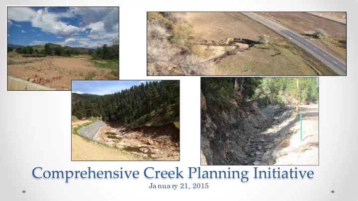
SLIDE 1
Comprehensive Creek Planning Initiative
Ja nua ry 21, 2015
Comprehensive Creek Planning Initiative Ja nua ry 21, 2015 - - PowerPoint PPT Presentation
Comprehensive Creek Planning Initiative Ja nua ry 21, 2015 Watershed Recovery Future Creek Long-Term Immediate Emergency Projects Vision Threat Response Assessment and Mitigation Funding and Watershed Implementation Master Plans
Ja nua ry 21, 2015
Future Creek Projects Funding and Implementation Emergency Response Immediate Threat Assessment and Mitigation Long-Term Vision Watershed Master Plans
nitia tive
e e db a c k
nitia te d to e nsure c o unty-wide vie w o f c re e k re c o ve ry a nd re sto ra tio n
mitig a tio n pro je c ts
ma ste r pla nning pro c e ss
E nabling F lood Re c ove r y thr
Wate r she d Planning
tne r ships
c e s
*F
unding fo r pro je c t imple me ntatio n, lo c al matc h ne e de d
Emergency Response
Long-Term Vision Watershed Master Plans
pro c e ss a nd kic k-o ff c o mmunity me e ting s
wo rksho ps
ma ste r pla ns
Emergency Response
L ittle T hompson Rive r
Emergency Response
Long-Term Vision Watershed Master Plans
ain Cr e e k Emergency Response
Long-Term Vision Watershed Master Plans
L e ft Hand Cr e e k Emergency Response
Long-Term Vision Watershed Master Plans
F
mile Cr e e k Emergency Response
Long-Term Vision Watershed Master Plans
Coal Cr e e k (Uppe r Re ac he s) Emergency Response
Long-Term Vision Watershed Master Plans
Plan Completion: November
Long-Term Vision Watershed Master Plans
Poor Excellent Recommendations: Consider opportunities for improved meanders, habitat, vegetation, etc.; need to create more complexity within the channel No further management recommended
Long-Term Vision Watershed Master Plans
Left Hand Creek
Good
In tact section of lower Left Hand Creek (on BoCo Open Space). This reach largely in tact due to functioning, connected floodplain.
Poor
Tight bedrock pinch led to stripping of alluvium in James Canyon, ultimately destroying the roadway and the pre-flood channel.
Long-Term Vision Watershed Master Plans
Project Descriptions
Long-Term Vision Watershed Master Plans
Long-Term Vision Watershed Master Plans
F
T ie r 1 - Pr
e duc ing flood r isk due to post- flood c onditions
Re a c h 1 – Re mo va l o f Se d ime nt a g g ra d a tio n fro m the c ha nne l ne a r Mile Ma rke r 1.1 Re a c h 1 – F
Re a c h 3 – Asse ssing the sta b ility o f e xisting wa lls a nd mo d ifying if ne c e ssa ry Re a c h 3 – F illing a nd re ve g e ta ting a vulsio n a re a s Re a c h 3 – Insta lling d e b ris ra c ks a nd sta b ilizing the b a nks o f Ing ra m Gulc h Re a c h 4 – Re mo va l o f se d ime nt a g g ra d a tio n fro m the c ha nne l a nd flo o d pla in ne a r Mile Ma rke rs 5.1, 5.8, a nd 6.3 Re a c h 4 – Re mo ving a d e b ris ja m in a hig h a vulsio n risk a re a ne a r Mile Ma rke r 7.7
T ie r 2 - Pr
e am stability and pr
e c ove r y
All Re a c he s – L
All Re a c he s – Inc re a sing in-stre a m ha b ita t All Re a c he s – Re ve g e ta tio n Re a c he s 1, 3, a nd 4 – Ba nk Pro te c tio n Re a c h 3 – Re lo c a ting F
Re a c h 4 – Re mo ving a te mpo ra ry b e rm ne a r Mile Ma rke r 7.2 a nd b a nk pro te c tio n
T ie r 3 - Pr
e as with low r isk to infr astr uc tur e
Re a c h 2 – F illing the pre -flo o d c ha nne l to re d uc e a vulsio n risk
F loodplain Mapping Emergency Response
Boulder County Floodplain Management Program
Master plans identify:
FEMA flood insurance rate maps are needed
F loodplain Mapping- St. Vr ain Cr e e k
$68 millio n*
e ft Ha nd $20 millio n**
$2.6 millio n*
and cost estimates
$1.6 millio n
*Cost estimates for all Tier 1 projects with unmet needs **Cost estimates for all of the top 5 projects with unmet needs
Long-Term Vision Watershed Master Plans
Pla n Use
ra me wo rk a nd g uida nc e fo r re c o ve ry a c tio ns
nfo rme d b y sc ie ntific da ta
unding to o l
Emergency Response
Lon-Term Vision Watershed Master Plans
Long-Term Recovery
Proje c t Imple me nta tion
ndividua l pro pe rty o wne rs
pa rtic ipa te / g ive a ppro va l fo r a ny pro je c ts
Emergency Response
Long-Term Vision Watershed Master Plans
Long-Term Recovery
Proje c t Imple me nta tion
pro je c t de sig n
re vie w, pe rmitting , e tc .)
unding
Emergency Response
Lon-Term Vision Watershed Master Plans
Long-Term Recovery
Post- Ma ste r Pla n Coa litions
Emergency Response
Long-Term Recovery
ain
g o ve rna nc e struc ture o f po st-ma ste r pla n Co a litio n
L e ft Hand
e ft Ha nd Wa te rshe d Ove rsig ht Gro up (L WOG) to se rve a s wa te rshe d c o a litio n
WOG Bo a rd e xpa nding re pre se nta tio n
F
mile
ire Distric t pursuing pro po sa l to ho use a nd de ve lo p c o a litio n
County L and Use r e vie w and pe r mitting
with ma ste r pla n re c o mme nda tio ns fo r stre a m a lig nme nt, c ha nne l se c tio n de sig n, a nd b a nk sta b iliza tio n
a nd Use Co de a lre a dy upda te d fo r use
info rma tio n
b e st a va ila b le info rma tio n in re vie ws, inc luding c re e k pla ns
Emergency Response
Long-Term Vision Watershed Master Plans
Long-Term Recovery
County L and Use r e vie w and pe r mitting
a nd Use Co de
imite d I mpa c t Spe c ia l Re vie w, Artic le 4-601.A.12
300.C.7.a Emergency Response
Long-Term Vision Watershed Master Plans
Long-Term Recovery
Sample language : Ar tic le 19, 19- 300, C.7.a
“T he pro po sa l sha ll no t po se o r c re a te a sig nific a nt po te ntia l sa fe ty ha za rd whe n e va lua te d a g a inst e vide nc e o f a c tua l da ma g e c a use d b y the 2013 E xtre me Ra in a nd F lo o d E ve nt (inc luding b y the E ve nt’ s re la te d ha za rdo us fo rc e s suc h a s flo o ding , de b ris flo ws, ro c kfa lls, mudslide s, to po g ra phic c ha ng e s o r insta b ility, dra ina g e c ha nne l shifts, a re a dra ina g e syste m impa irme nts o r fa ilure s, a nd so il sa tura tio n)a nd b e st a va ila b le info rma tio n (inc luding b ut no t limite d to hydro lo g ic e va lua tio ns to de te rmine pe a k flo ws, flo o dpla in ma pping studie s, Co lo ra do Ge o lo g ic Surve y la ndslide o r e a rth/ de b ris flo w da ta , upda te d to po g ra phic da ta , a nd c r
e e k planning studie s).”
Emergency Response
Long-Term Vision Watershed Master Plans
Long-Term Recovery
County L a nd Use re vie w a nd pe rmitting
lo o dpla in de ve lo pme nt pe rmit still ne c e ssa ry to a sse ss impa c ts o f pro je c t in re g ula te d flo o dpla in
pe rmitting pro c e sse s b y de ve lo ping “o ne pro je c t” invo lving multiple pro pe rtie s
Emergency Response
Long-Term Vision Watershed Master Plans
Long-Term Recovery
Cr e e k Re c ove r y and Re stor ation Pr
am Ac tivitie s
funding a pplic a tio ns
nitia te pro je c t de sig ns (30%) b y de pa rtme nt sta ff, whe n funding se c ure d
imple me nta tio n
a c tivitie s
CD)
Emergency Response
Long-Term Vision Watershed Master Plans
Long-Term Recovery
Feedback on Plans
January 21
January 22 Adoption
February 26
Long-Term Vision Watershed Master Plans
Julie Mc K a y Pho ne : 720-564-2662 E ma il: jmc ka y@ b o ulde rc o unty.o rg We b site : www.Bo ulde rCo untyCre e kPla n.o rg